Upcoming

Kashmir Great Lakes Trek

13+ interested

0/5

Kashmir Great Lakes Trek - Blankets Of Clouds

  • Price: Rs. 12399
  • Region : Ganderbal, Jammu & Kashmir
  • Duration : 8 days
  • Distance : 72 km
  • Altitude : 13,750 ft ft.
  • Grade : Moderate

Enquiry Now!


Overview

Region :- Kashmir, J & K
Duration :- 8 Days
Grade :- Moderate
Max Altitude :- 13,750 Ft.
Approx Trekking Km :- 72 Kms.

The Kashmir Great Lakes Trek is in no need of an introductory treatise. It presents the proem in itself. You can draw a preface of it by just hearing its name. Kashmir is a wonderful place and if you are on a himalayan trek you are bound to taste the natural beauty and adventure. The trek to the Kashmir Great Lakes Trek offers a lifetime experience of vintage memories that are so wonderfully tiring. The thundering silence of the Kashmir lakes and its virgin beauty is spell bound. Apart from the lakes, even the barren milky snow clad mountains stand out in might and proud.
The location of this trek, as obvious, is Kashmir, also known as the paradise of the earth. The trek duration calculates around 7-9 days and this trek is often graded as moderate in regards to the trekking challenges. The elevation circles around 13000 feet and the distance paths approximately 63 kms. On such a fulfilling trek you will learn so much learn about yourself- in a trifecta – physically, mentally and emotionally. For a trekker, nothing can replace and prepare him for those paramount and conflicting emotions that whether his body will take so much of strain and whether he will make it or not. But the joy on reaching the destination is obvious. This trek will always be happy and a cherishing trek for the trekkers that comes in handy with a few preparations.
As the trek to the Kashmir Great Lakes Trek demands physical fitness, you must take good care of your health, shape yourself well and be fit and fine. Trekkers can train themselves by working out regularly in gym along with running, walking on incline, cycling, cross-training and stretching on a daily basis. Along with physical health mental fitness is important equally.
Coming to the details of the trek, it generally starts from almost 3 kms out of Sonamarg, on the Srinagar road. You can find few dhabbas on your way. Its better to the trekkers to pick up short eats here for the next trace of a dwelling place will be at Naranag that would be probably mark the end of the track.
A few of the trail and the trek enters a green meadow, overlooking the Sonamarg town. At the top of the meadows trekkers reach the starting line of Maple and Pine trees. What follows is a lovey-dovey deep dense forest of Maple trees. Such an experience has always been unique to this trek in India.
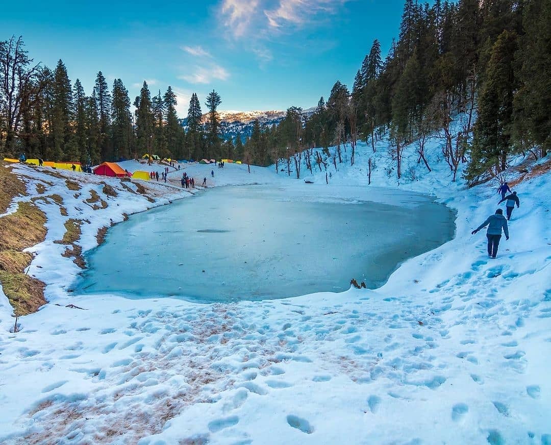
You will always be amongst the meadows throughout this trek. The best time to enjoy the Kashmir Great Lakes trek is in between the June and September as the greenery and the blooming flowers are at their best during this calendar period. Its so that a beginner in trekking can also join this trek.
Trailing through the Maple trees uphill, trekkers can enjoy the crystal clear view of the nearby villages downhill and especially the Sonamarg village. Every bit of nature nestles to make a wonderful picture. From here the trail slopes down into yet another meadow lined by the Silver Birch trees and a few shepherd huts. Massively tiny brooks struggling through the meadows and snowy peaks of small mountains mark the land of Shekdur. Shekdur is the only camp site with trees on this trek. It is therefore an add-on in your clicks. The sun rays piercing through the forest, that comes on your way, on further trailing, makes it a nice show of dark and light. Further the trail climbs back into a river valley which is the beginning of Nichanai. You have entered into a wide valley encompassed by the peaks.
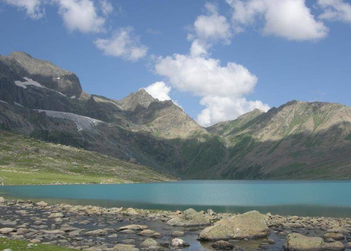
After crossing a tunnel-like Nichnai pass followed up by the miles spreading meadow and the cascading waterfall with the icy cold composition of two atoms of Hydrogen and one atom of Oxygen, comes the Vishansar Lake. The first impression that the lake imposes upon the trekker is that of its volume and surrounding provided by the four mountains. It is been followed up by the Kishansar Lake which is only at a distance of 1.2 kms. It has a big meadow stretching by its side. The trail follows up through a ridge. You can see the loveliest view of the two gone-by lakes together from the Gadsar pass which is the highest point of this trek.
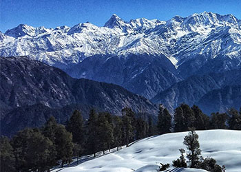
Then the time comes to descend. On the way back, the eye captures the view of Yamsir Lake, the nameless lake and the Gadsar Lake which are all connected by all stream. Further you will come to a place called Maengandob where few deep craters are found. The landscape ahead is magnificent for you get to visit Satsar Lakes-collection of seven Lakes and further the twin lakes among which the bigger is the Gangabal and the other one to arrive is Nundkol. On your last destination two Naranag, you are greeted with awe-inspiring glaciers, meadows as well as mountain peaks.
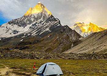
The trek to the Kashmir Great Lakes Trek will provide to the trekkers a perfect flavour of all hues of terrain- innumerable meadows, snow clad glaciers and pinnacles, passes, rocky barren lands, struggling streams. The trail to the Great Lakes is worth trekking. It does justice to all the expectations of a trekker. No individual will ever undergo but this trek will make you undergo. It is a path to heaven and its virgin serenity.
While trekking, trekkers must be equipped with the necessary equipments. Apart from the professional trekking gear, stuffs inclusive of trekking shoes, trekking pole are important specifically. Trekkers must never compromise with their body requirements. Its better to understand your body need and not going by the choice of some other fella. The Kashmir Great Lakes Trek is not a childs game but even a child of ten years can go on this trek. The luggage or the carry bag should be as light as possible. It will be in your comfort.
Who can go
First timer can apply, should have some interest in trekking and mountaineering.
The climber must be fit and have sufficient stamina to cover 5 km of distance in 30 minutes without a stress.
The climber should be able to carry a 10-15 kg backpack.
Heart problem, high blood pressure, asthma, and epilepsy cannot be reconciled on this mission. The climber must not have the conditions mentioned above.
  • Altitude: 7800 ft
  • 90 kms drive from Shrinagar, approx 3 hours.
  • If booked in advance, The Crazy Mountaineers can arrange pick up from TRC at 3pm
  • Our campsite is near the Sindh river (Shitkadi Village).
  • Since there are no shops around ensure that you have all that you need already.
  • Remember to carry your ID proof in original and 2 photo copies as we have to submit them at the army check post.
Depart to Sonamarg in the afternoon. It is 3 hrs drive from Srinagar.
PrivacyPrivacy Facebook Twitter Linkedin Reddit Word to Clean HTML ConverterWord Editor HTML Undo New page indentation compress encoding option ico option2 option3 option4 option5 option6 option7 option8Clean
  • Altitude: 7,800 ft to 11,500 ft
  • 11 kms trek, approx 8 hours
  • After the breakfast we trek to Nichnai via Shekdur.
  • The trail takes you through meadows, dense forests with Maple, Pine and Bhoj trees.
  • After approx half an hour, we get an army check post where we have to submit our ID proofs.
  • While you are at it, you can enjoy an awesome view of the Sonmarg Valley or the Thajiwas Glacier.
  • The trek from Shitkadi to Shekdur is goes through thick forests of pine trees and will take approx 2 and half hours.
  • At Shekdur, you can indulge in instant noodles and an omelette if you wish to.
  • We follow the Nichnai Stream as we trek from Shekdur to Nichnai.
  • We have lunch at the Nichnai stream, after Shekdur.
3 hour ascent followed by 1 hour descent and finally a gentle ascent to Nichnai (6 hours, 9kms)
The trek starts 3 kms out of Sonamarg, on the Srinagar road. Exactly at the 3 km mark, spot a lone Dhaba on the right. The place also sells packaged water, biscuits etc and is your last place to pick up short eats. The next trace of dwelling civilization is only at Naranag at the end of the trek.
A jeep track diverts to the right off the main road at the shop. The track goes down to the level of the Sindh river flows in between the mud track and the main road. The trekking trail starts along the track but quickly diverts higher up. 10 minutes into the trek, the trail bends left and enters a green meadow. The meadow directly overlooks the Sonamarg town. In half an hour you are at the top of the meadow where Maple and Pine trees start. At the tree line, the trail quickly descends to a tiny brook and then climbs again. What follows next is a lovely dense forest of Maple trees. Walking on the green bed of grass amidst the Maples is an experience unique to Kashmir in India.
For the next hour and a half, the trail winds up through the Maple trees. Stick to the trail heading uphill as the ones going down head to some of the nearby villages. The trees give way to clearings in between. Turn around and see the view of the Sonamarg valley which gets better and fuller as you gain height. The Maple forest ends at the top of the ridge and the other side a meadow gently slopes down. Spend a few moments at the ridge taking in the views of the Sonamarg and its neighboring valley. The streams, the meadows, the pines and the town nestled make a wonderful picture. The climb is now over and the trail slopes down into a meadow. The meadow is lined on the left by Silver Birch trees and a few shepherd huts. The carpet of green rolls down from the trees to the end of the 40ft wide meadow. Small brooks which cross the meadow serve as water sources. On the right are small peaks with snow powdered on top of them. This is Shekdur. If you plan to have a short days trek on day one, this is where you pitch your tents for the day. It takes an average trekker about 2 1/2 hours to reach the meadow from the road head and add another half an hour if you decide to break the days trek at the end of the meadow.
Shekdur is a beautiful campsite surrounded by Bhoj trees. This is the only campsite with trees on this trek and therefore adds a good variety to your moments and photographs. If you have started from Srinagar in the morning, make Shekdur your first camp. The next campsite Nichnai is atleast 2 more hours away.
If you started from Sonamarg, Shekdur, just three hours into the trek is too early to camp. Have lunch at the meadows and move ahead to Nichnai. The meadow of Shekdur stretches for half an hour. The gentle descent on the meadow ends in a forest of Bhoj or Silver Birch. Take the trail that goes in the middle of the forest and continue to descend gently. Watch out for the sun rays making their way in between the thick foliage making it a nice show of light and dark.
In 45 minutes, you reach the end of the Birch trees and the trail goes down and climbs back into a river valley. The river valley is the beginning of Nichanai. The trail now is along the right bank of the river going upstream. Look behind to see snow clad peaks from Sonamarg valley. You are now in wide valley but enclosed by mountains on either side. The river, which joins the Sindh eventually flows in speed through the valley. The first 30 minutes is over rocks and your mules will walk very slowly over here.
An hour into the river valley green patches devoid of rocks open up. The river valley widens and you can see the green meadow widening in between the two mountain ranges. Far ahead lie triangular twin snow clad peaks. Choose a flat ground to pitch tents and end the first days trek.
  • Altitude: 11,500 ft to 12,000 ft via 13100 ft
  • 12 kms trek, approx 7 hours
  • Trek from Nichnai to Nichnai Pass is of approx 1 and half hours ascent.
  • At the top of Nichnai Pass you can get B.S.N.L network, which is the last point under mobile coverage area.
  • From Nichnai pass to Vishansar there is a descent.
  • At Vishansar campsite, lunch will be offered.
  • We can visit the Vishansar Lake which is just 15 minutes walk from the campsite
  • The first lake of the trek and one of the most beautiful ones.
  • If the trek is in July, the lake will be frozen. Otherwise, we can do fishing at the lake with permission from Srinagar Fishing Department.
  • Vishansar is visited by hoards of sheep and their shepherds are known for interesting stories.
  • The campsite is a unique place with an open ground and you can play volleyball, cricket etc.
  • Beware of dogs at campsite
Medium climb to Nichnai pass 13,500ft. Small descent followed by a long flat meadow walk ending near Vishansar Lake. (12 kms, 6 hours).
The days trek is a long walk on meadows with the scenery changing for the better all along. Start by 8 am to give you enough time en route to enjoy the meadows. Your first destination for the day is to cross the Nichnai pass or Vishansar Berry. The pass is visible at a distance from the campsite. It lies just to the right of the twin snow clad peaks. After half an hour of walking along the river, cross the river to move to its left bank. The next one hour, walk on the left bank. Notice that the trail slowly starts ascending as you traverse through the meadow. The following one hour is a climb to the pass.
As you climb, notic e a small lake at the foot of the mountains. The lake is deep blue in colour and you can sense your expectations raising of the main lakes to come on this trek. The pass is deceptive. The ridge seen from the meadow below is not the pass. The trail turns inwards twice and only then does the Nichnai pass come up. From the Nichanai pass, watch the Sonamarg valley and the trail you came from. BSNL phone network tends to work here most times. This is the last point on the trek where you get phone network. The next sign of network is only when you move beyond Gangabal.
The Nichnai pass feels like a wide tunnel. On the left stand a series of snow clad peaks. There are no peaks on the right but the land raises on the right too. Nichnai pass is at an altitude of 13,500 ft. You are just into your second day of the trek and this by any standard is a very fast ascent. It is not uncommon for people to feel the altitude on the climb to Nichnai pass. The good news is that the trail descends from here on. The rocky trail descends rapidly. In the next hour the rocks give way to grass. Red flowers spring out next to your feet. What you see ahead is a wide green meadow stretching for miles with mountains lining the sides. A new river flows down from the pass into the meadow ahead.
Stop here and take in the view of the peaks, the river below and the flowery meadow. Notice to your left a big waterfall splashing down the mountain cliff and joining the river. From the waterfall, the rapid descent ends and you are now walking through the flat wide meadow. On the left are the classic snow clad Himalayan mountains but notice on your right, grey and barren mountains resembling the Ladakh ranges. Walk along in between the two ranges over the lush green carpet of grass. Two main streams flow through the valley. Stick close to the stream on the left. In half an hour, brace yourselves for another stream crossing for the day. The water is icy cold.
Continue in the meadow for an hour and a half until you reach the end of the valley. Another stream flows perpendicularly from your left to your right. This stream originates at the Vishansar lake which is a bit higher on your left. The lake is not seen yet and cannot be seen from the campsite. Pitch your tents anywhere beside the stream coming from the lake. There is ample camping space. The Vishansar lake lies half a km to the left and 100ft higher from the campsite. Head left and follow the stream without crossing it. The lake is two mounds away and takes about 7 minutes to reach. The first impression you get on seeing the Vishansar lake is that it is big. It lies nestled below 4 mountains.
The Kishansar peak though 0.5 km away, reflects in the lake. The reflections are wonderful when the lake is still. The color of the lake depends on the time of the day and the clouds in the sky. Early in the morning, before the sun really shines, expect clear colorless water. The lake starts getting its colors when the sun shines. On a clear sunny morning, the water is absolutely blue. Clouds and the evening sun make it look greenish blue in the later half of the day. Whatever be the color the lake looks wonderful and it is worth catching a glimpse of the lake in all its hues.
These lakes are full of trouts and trout fishing is popular. Obtain a permit from Srinagar for fishing.
  • You may visit Kishansar lake, which is at approx 1 and half kms from our camp site.
  • If the weather is not good we will use acclimatization day at vishansar or else move towards next camp site, rest day can be use at Gangbal camp site.
  • Altitude: (12,000ft) to (12,000ft) via (13,750ft)
  • 14 kms trek, approx 10 hours
  • We start the trek earlier than usual.
  • The trail passes from Vishansar to Gadsar, via Gadsar pass the highest point of the trek.
  • From Vishansar, the trail takes a steep ascent till Gadsar Pass.
  • We can see the Kishansar Lake on the way.
  • From the Gadsar pass till the camp site, we descend gradually.
  • We can spot the Gadsar lake en route.
  • You might also spot the Glacier of Gadsar Lake.
  • After the Gadsar lake, we will reach the campsite in 2 hours.
  • Just a few minutes before our campsite, we will have another army checkpoint and we will have to share our ID proofs with them.
  • Pack lunch will be provided
Steep 2 hour ascent followed by a steep descent followed a gentle walk in the meadows. (5 hours, 10 kms)
The next lake in series is the Kishansar lake. The Kishansar lake lies just about ½ km away and 500ft higher than Vishansar. The Kishansar lake lies at the base of the Kishansar peak. It takes about 45minutes to reach Kishansar lake from the campsite. Move right towards the stream and cross it where it is easy. The trail climbs up on the right side of the Vishansar lake. There are multiple tracks here. For those keen on photography, the one going up is more attractive as you get the view of the meadow and the lake from a height. For those who prefer an easier trail, stick to the flatter trails. Though the two lakes are only 1.2 km away, there is no point where the two lakes are visible together.
If you choose not to camp next to Gadsar, the next place to camp would be the Gadsar army camp. Continue on the downward trail from Gadsar and in half an hour the valley widens up. Spot another blue lake on the left of the valley. Notice the snow clad mountains now give way to lower barren mountains. You have lost considerable altitude again. In another half an hour down the trail, a few Shepherd huts come up. Continue downhill and at the end of the third half hour, the army camp comes up. Gadsar army camp is just a small hut housing 5-8 army men. To move beyond the army camp, one needs permission from their Head quarters. The Head quarters is 3 miles further away down into the tree line near a village. The Gadsar camp communicates with the HQ through walkie talkies. The HQ is equipped with a satellite phone of the army.
If you are near the Gadsar army camp, it is best to report to them as soon as possible. It takes 2-3 hours for their green signal to come through. All details of the trekkers and staff including original id cards are recorded, collected and checked.
  • Altitude: 12,000 ft to 12,000 ft
  • 9 kms trek, approx 6 hours trek
  • Mid July to mid August, the trail is laden in vibrant flowers.
  • We need to share our IDs at another army check post en route. .
  • Moving on, we see two small lakes which are often mistaken as Satsar Lakes.
  • We will visit the Satsar twin lakes, in the afternoon, which are approx 1.3 h
  • Stasar twin lakes are also known as mengen top.
  • Those twin lakes are between the middle of the mountain.
Gentle descent for 1 hour followed by a steep ascent for 3 hours followed a flat meadow walk. (6 hours, 12 kms)
From the army camp move left towards the stream. The trail crosses the stream and heads up the mountain. The altitude at the stream is 10,600ft. The Satsar camp is at 12,000ft and almost 10 kms away. Crossing the stream is the easiest way to trek. If one really wants to avoid getting their feet wet in the icy cold water, then head to the bridge which a kilometer away and cross the stream. The climb up is steeper if one goes to the bridge.
After crossing the stream, take the trail that goes up the mountain. The trail now looks like a typical western ghat trail. The terrain feels very similar. You are just above the tree line. Trees and the river valley are visible below you. The hour and a half long climb takes you up by 1100ft. Once beyond the 11,500ft altitude, the climb graduates to a traverse. The trail bends round to the left and leaves the river valley. You are now walking on a flat trail surrounded by mountains on a meadow. To you right are a few deep craters. This place is called as Maengandob.
The landscape ahead is captivating. Isolated mountains stand in front. Towards the right is a small ridge. In between is a flat green bed with a stream flowing in between. Choose to camp here if Gadsar lake was your last camp. If the army camp was your start, it makes sense to cover a little more distance today and camp near the first of the Satsar lakes. Satsar is actually a collection of 7 lakes. You can actually find 4 or 5 lakes with water, depending on the season you choose to trek.
Beyond the ridge on the right is the Satsar army check post. It is the 3rd line of defence from the LOC. The same process of ID checking, collection and questioning repeats here too. Finish this today so that tomorrow is a clean day of trekking.
Ten minutes out of the army camp is the first of the Satsar lakes. The lake is pretty big and looks picturesque in its green setting with mountains in front. Choose a place to camp here for the day.
  • Altitude: 12,000 ft to 11,500 ft 13000
  • 11 kms trek, approx 6 hours
  • We walk on rocky paths for approx an hour and ascend till Jazz Pass.
  • At the pass, you can enjoy views of the 4 lakes, Mt. Harmukh and its glacier.
  • From the pass we descend till the Gangbal lake and camp at Nandkol lake.
  • We visit the Gangbal Lake, which is one of the largest lakes in the trek.
  • Post dinner, a team of Kashmiri staff will perform their traditional songs and dance.
Mild ascent followed by gradual descent followed by long steep ascent and long steep descent followed by gradual up and down walk. (6 hours, 9 kms)
The days trek goes up and down replicating the trek as a whole which mostly goes up and down. Trek up half an hour out of camp, to reach the biggest Satsar lake. The terrain is bouldery and it is more of a boulder hopping exercise than anything else. The biggest of the Satsar lakes is also the last in the sequence. After the last lake the trail starts to descend. Continue for half an hour on the main trail until you see the forest line ahead to your left. The right side is a ridgeline about 1000ft higher. It is time to gain height again. The altitude at the base of the climb is 11,800ft. Take the zig zag pony track to climb up to the top of the first ridge. A 45 minute trek with limited breaks will see you on top of the first ridge. Once on top, you see two more ridges to climb. The trail from the base to top is barren and rocky. Looking behind at the opposite mountains, spot the Gujjar huts amidst the tall pines. You will not fail to notice the bareness of the mountains here and the greenery on the other side.
The Nundkhol lake lies at the base of the Harmukh peak. The Harmukh glacier hangs on the the sides of the rocky edges of the mountain. Both the Gangabal and Nundkhol are famous for trout fishing.
The Gangabal lake is about 20 minutes away from Nundkhol. A fiery stream flows on the right of the two lakes connecting them. The stream has to be crossed to go to Gangabal from Nandkol. Do not try to cross the stream at the lower levels but go all the way to the bank of Gangabal and on the right you find a good man made bridge laid out. Gangabal is huge. A parikrama of either of the lakes will easily take an hour.
  • Altitude: 11,500 ft to 7,450 ft
  • 15 kms trek, approx 7 hours
  • The trail is a descent till the last point of the trek – Naranag, so take care of your knees and ankles.
  • The trail will pass through pine tree forests.
  • On advance booking, The Crazy Mountaineers can arrange transport to Srinagar at a charge.
  • After the 70 kms drive, you will reach Srinagar by 6:30 pm.
* Please note that prepaid sim cards do not work in Kashmir.
Dont forget your ID proof in original and 2 photo copies.
On Day 8, youl reach Srinagar between 6:30 pm and 7:30 pm. You can book your travel any time after 8 pm.
Gradual descent followed by steep descent. (6 hours, 11kms)
The days trek is a killer on your toes and knees. From the Gangabal campsite head down along the stream towards the tree line. Dont walk beside the stream but walk along the ridge on the right. 30 minutes into the trail, your aircel phone could get glimpses of network just enough to tell home that you are alive. The ridge ends and you descend to a green flat meadow on the right. The Harmukh peak looks impressive when you look back. The green meadow has little yellow flowers growing all over and you start walking gingerly to avoid stepping over them.
An hour out of the campsite, you hit the fringes of the tree line. Pine trees line the meadows and you also see traces of civilization with the presence of a log hut. Do not walk into the forest directly but stick to its fringes and walk towards the right. As a trademark of this trek, you dont lose altitude now but start to climb up a bit. You drop to 10,800ft at the tree line but climb again to 11,000ft. For about 6 kms you never really lose altitude and you are forever around the 10,800ft mark making your way in and out of the Pine forest and finally entering it fully. Only after walking for 2/3 of the distance does the true descent begin. The descent is now really steep. The trail is a well trodden muddy one through the thick of the pines. The last 4 kms sees you dropping more than 3000ft. It is not rare to spot lot of people trekking up here from Naranag headed only to Gangabal.
Naranag slowly comes in sight at around 8500ft but there is quite a bit more to go. The last stretch of the last day does become an endurance test but soon the stone paved village track comes up and in no time you enter the main road of Narnag.
By Air :-
Most major air carriers like Indian Airlines (www.indian-airlines.nic.in) Jet airways (www.jetairways.com) and Indigo operate daily flights to Srinagar. Reaching Srinagar by flight from New Delhi is the most convenient way.
By Train :-
Jammu is the nearest railway station to Srinagar, which is at a distance of 290 km. Jammu railway station is well connected to all major cities in India by rail. Direct train services are available from Delhi, Chennai, Bangalore and Trivandrum.
By Bus:-
Srinagar is linked by the National Highway 1A to the rest of the country. J & K state road transport operates comfortable buses from Jammu. The Journey takes about 10 hours to reach Srinagar.
Inclusions :-
1. Accommodation. (Camping)
2. Meals while on trek (Veg & Egg)
3. Trek equipments like Sleeping bag, mattress, tent, kitchen tent, toilet tent
4. Trekking Permits
5. First aid medical kits and oxygen cylinder.
6. Qualified & experienced trek Leader, Guide and Support staff
Exclusions :-
1. Transport from Srinagar to Sonmarg and Narnag to Srinagar
2. Hotel Stay in Srinagar.
3. Food during the transit.
4. Insurance.
5. Mules or porter to carry personal luggage.
6. Anything not specifically mentioned under the head.
Transportation: The cost of transport from Srinagar to Sonmarg and return from Narnag to Srinagar has to be borne by the participant. Trek The Himalayas has arrangements with local transporters to pick up trekkers from Srinagar. The vehicles will leave Srinagar at 3.00 pm and reach Sonamarg by 6.00 pm.
Srinagar Accommodation: The stay at Srinagar on the last day is not included in the trek fee. However we can assist you in booking a hotel or a houseboat for the same. Most participants opt for the Trek The Himalayas pick up – and we assume the same in your case. In case you do not want the Trek The Himalayas pick up, please let us know at least 15 days in advance to the start of the trek. Intimation is by email only at info@trekthehimalayas.com
Note : Normally The Crazy Mountaineersexpect to carry your personal luggage on your own, if you wish to offload your backpack, you can give it to Mule.
Charges of offloading backpack:-
INR 2100/- if you make an online payment, 10 days in advance
INR 2400/- if you inform us after reaching Sonmarg
The backpack cannot weigh more than 11 kgs. Backpack should have waterproof cover. Suitcases/strolleys/ bags will not be allowed.
Paying the Trek/ Adventure activity fee: The fee can be paid by online transfer/check deposit/ demand draft. Instruction for payment will be forwarded along with your confirmation email. When your transfer is done, please e-mail us a confirmation mail with your transfer details, so that we can follow up your reservation efficiently.
When to book: It is wise to make your booking at least two months in advance. However, if you want a good deal on your domestic/international flight, we recommend organising your trip at least five months in advance. (Please contact us if you require a late booking)
Basics Gear
Back pack & rain cover (50 - 60 ltr) with comfortable shoulder straps
Day pack + rain cover 20 - 30 ltr (If hire a mule or porter)
Walking stick Advisable (At least one)
Head torch 1 Nos.
Water bottle/Hydration pack 2 bottles of one litre each
  People who use hydration pack
  1 hydration pack and 1 bottle of one liter
  Carry at least one thermos flask
Snacks Energy bars, dry fruits, electral/ors
Personal Medical Kit Consult your doctor
Be comfy at Kashmir Great Lakes
T-shirts 2 Full sleeves (Non-cotton)
Fleece T-shirts 1 Nos.
Fleece jacket 1 Nos. (Alternative: a woollen sweater)
Down feather / Hollofil jacket 1 Nos.
Wind & waterproof (jacket & pant) 1 Pair
Thermal inners (upper and lower) 1 Pair
Trek pants 2 Synthetic (avoid shorts, fitting denims, capris)
Poncho 1 Nos.
Think about your head
Sun cap 1 Nos. (One that covers the neck as well)
Woolen cap 1 Nos.
Balaclava 1 Nos.
Neck-gaiters 1 Nos.
Sunglasses Dark with side cover, it should be U/V protected.
        People who wear spectacles- 
  (A)- Use contact lenses. (Not for Chadar trek)
  (B)- Photo chromatic glasses. 
Mind your step
Trekking shoes 1 Pair (Waterproof, high ankle with good grip)
Floaters/flip-flops 1 Pair (Optional)
Cotton socks 5 pairs
Woollen socks 3 pairs
Gaiters 1 Pair (The Crazy Mountaineers team will notify you if required)
Keep these handy
Waterproof gloves 1 Pair
Fleece/woollen gloves 1 Pair
Personal Utilities
Sunscreen cream Hand sanitizer
Moisturiser Antibacterial powder
Toilet Paper & wipes Toothbrush and toothpaste
Lip balm Quick dry towe
In the event of cancellation of trek/adventure activity services due to any avoidable / unavoidable reasons we must be notified of the same in writing. Cancellation charges will be effective from the date we receive advice in writing, and cancellation charges would be as follows: -

Cancellations prior to 24 days from the start of the trek

Book any other trek till one year or get 95% refund (Note: If the trek charges are more, the balance needs to be paid by the trekker)

Cancellation between 24 days and 14 days to the start of the trek

Choose to go for the same trek, with any other batch, till year or get 70% refund

Cancellation between 14 days and 10 days to the start of the trek

Choose to go on the same trek, in the same season, with any other batch or get 50% refund.

Cancellation less than 10 days to the start of the trek

Transfer your trek (same trek, same batch) to your friend. No cash refund.

Note:-

  1. Change of trek batch is dependent on the availability of seats in the batch.
  2. In case of transferring a trek to a friend, he/she should satisfy all the mandatory requirements put forward by THE CRAZY MOUNTAINEERS.
  3. THE CRAZY MOUNTAINEERS holds the right to change/cancel the policies, without prior notice.

Share Your Experience with us!

Rating

Recently Viewed Treks

Similar Treks

Kanamo Peak Trek

Rs. 12399 / person

  • Region : manali
  • Duration :7 days
  • Grade : Moderate
  • Altitude : 19,553 ftft
  • Trek Distance : 27km

Kedarkantha Trek

Rs. 5,999 / person

  • Region : Uttarkashi
  • Duration :5 Days
  • Grade : Easy - Moderate
  • Altitude : 12,500 ft
  • Trek Distance : 22 km

Har Ki Dun Trek

Rs. 10,499 / person

  • Region : Uttarkashi
  • Duration :7 Days
  • Grade : Easy - Moderate
  • Altitude : 11,200 ft
  • Trek Distance : 54 km

Gaumukh Tapovan

Rs. 15,399 / person

  • Region : rishikesh to uttarkashi
  • Duration :8 Days
  • Grade : Moderate - Difficult
  • Altitude : 4340m/14235ftft
  • Trek Distance : 46km

Rupin Pass Trek

Rs. 16,899 / person

  • Region : Dehradun to Dhaula
  • Duration :8
  • Grade : Difficult
  • Altitude : 15,250ftft
  • Trek Distance : 52km

Dayara Bugyal Trek

Rs. 8,999 / person

  • Region : Dehradun to Raithal
  • Duration :6 Days
  • Grade : Easy - Moderate
  • Altitude : 12,100ftft
  • Trek Distance : 23km